Back Arbil Afrikaans أربيل Arabic ܐܪܒܝܠ (ܡܕܝܢܬܐ) ARC اربيل ARZ Ərbil Azerbaijani اربیل AZB Эрбіль Byelorussian Арбіль BE-X-OLD Арбил Bulgarian আর্বিল Bengali/Bangla
Erbil ھەولێر Hewlêr | |||||||||
|---|---|---|---|---|---|---|---|---|---|
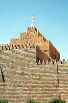
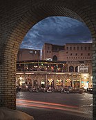
Top-bottom, R-L: Downtown Erbil Mudhafaria Minaret • Nature in Erbil Textile Museum • Citadel of Erbil Cathedral of Saint Joseph • View outside Erbil citadel Empire World | |||||||||
| Mga palayaw: | |||||||||
| Lua error in Module:Mapa_nin_kinamumugtakan at line 485: Dae mahanap an ispesipikong depinisyon kan mapa nin kinamumugtakan: "Module:Mapa nin kinamumugtakan/datos/Iraqi Kurdistan" an nag-iiral. | |||||||||
| Tagboan: 36°11′28″N 44°00′33″E / 36.191188°N 44.009189°ETagboan: 36°11′28″N 44°00′33″E / 36.191188°N 44.009189°E | |||||||||
| Country | |||||||||
| Autonomous region | |||||||||
| Governorate | Erbil | ||||||||
| Pamamahala | |||||||||
| • Mayor | Omed Khoshnaw | ||||||||
| Hiwas | |||||||||
| • Kabuuhan | 115 km2 (44 sq mi) | ||||||||
| • Kadagáan | 113 km2 (44 sq mi) | ||||||||
| • Katubigan | 2 km2 (0.8 sq mi) | ||||||||
| Elebasyon | 390 m (1,280 ft) | ||||||||
| Populasyon (2022 estimate) | |||||||||
| • kabuuhan | 1,612,700[2] | ||||||||
| Sona nin oras | UTC+3 (AST) | ||||||||
| Postal code | 44001 | ||||||||
| Area code(s) | 066 | ||||||||
| Websityo | HawlerGov.org | ||||||||
An Erbil (Arabic: أربيل, translit. Arbīl;[3] Plantilya:Lang-syr[4][5]), also called Hawler (Plantilya:Lang-ku),[6] sarong siyudad sa Irak. Ini an kabesera asin pinakadakul sa populasyon sa Ronang Kurdistan, Irak. An siyudad sakop kan Erbil Governorate[7] asin igwa ining tinatantyang populasyon na mga 1,600,000.[2]
- ↑ "ھەولێر". chawykurd.com. چاوی کورد. Archived from the original on 30 July 2021. Retrieved 2 December 2020.
- ↑ 2.0 2.1 "Population of Erbil in 2021 2022 – statistics".
- ↑ "أربيل" (in ar). Al Jazeera. https://www.aljazeera.net/encyclopedia/citiesandregions/2015/5/21/أربيل.
- ↑ "Search Entry". assyrianlanguages.org. Retrieved 2021-05-26.
- ↑ Khan, Geoffrey (1999). A Grammar of Neo-Aramaic: The Dialect of the Jews of Arbel (in English). BRILL. p. 2. ISBN 978-90-04-30504-5.
There are a number of variant forms of the name Arbel. The form Arbel, which is used throughout this book, is the Neo-Aramaic form of the name. The Arabic-speaking Jews of the town refer to it as Arbīl or Arwīl. In Classical Arabic sources it is known as Irbīl. The Kurds call it Hawler, which appears to have developed from the form Arbel by a series of metatheses of consonants. The name appears to be of non-Semitic origin. It is first found in cuneiform texts dating to the third millennium B.C., where it usually has the form Urbilum.
- ↑ "Hewlêr dixwaze Bexda paşekeftiya mûçeyan bide" (in ku). https://www.rudaw.net/kurmanci/kurdistan/160920198.
- ↑ Danilovich, Alex (2018-10-12). Federalism, Secession, and International Recognition Regime: Iraqi Kurdistan (in English). Routledge. ISBN 9780429827655.


